Herriman Rose Blvd./Main Street Intersection
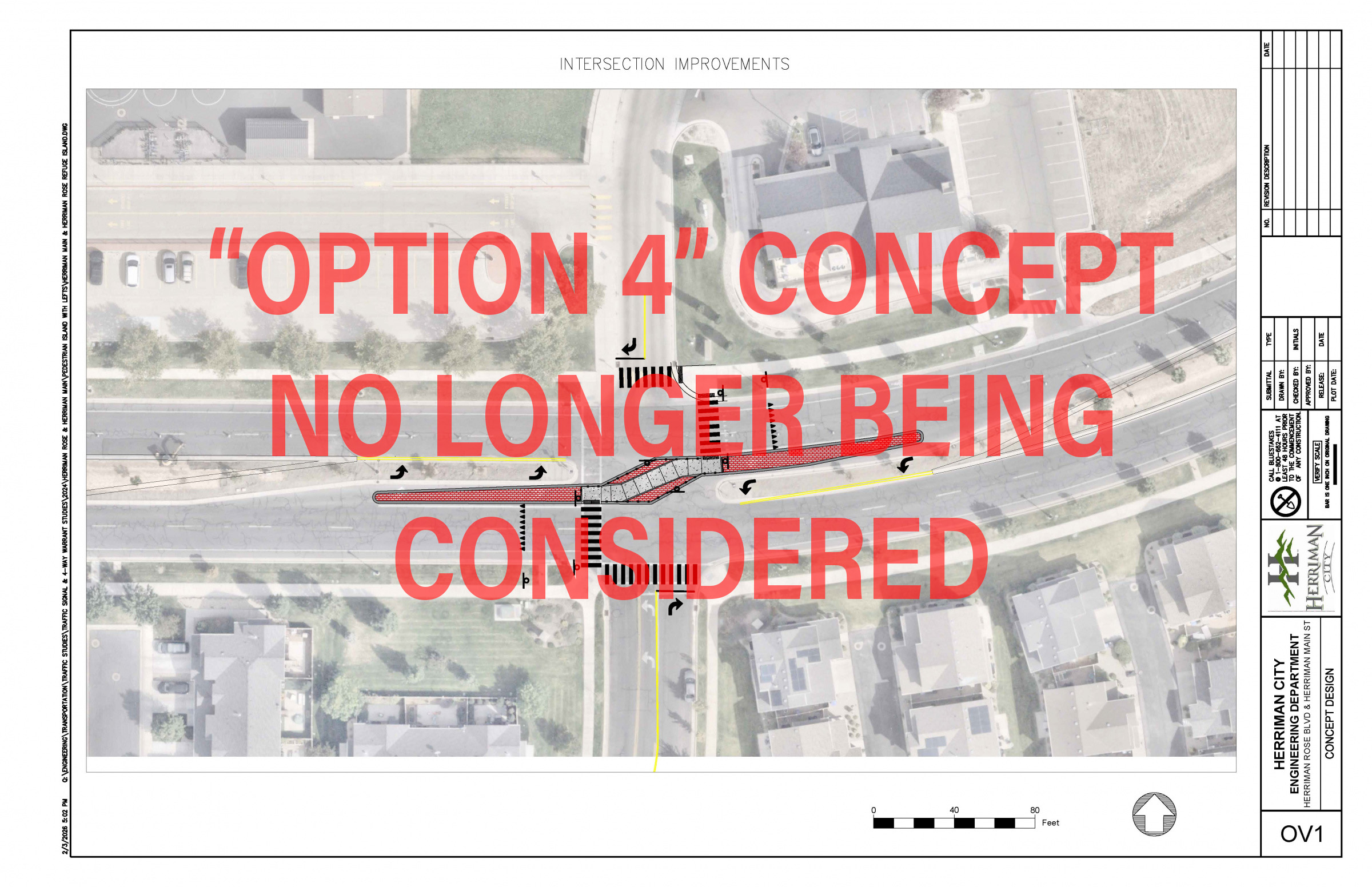
Image: Previously shared concept for "Option 4," which included a pedestrian refuge island and permanent restrictions on some vehicle movements. This concept will not move forward.
Project update
Herriman City has completed its review of the proposed intersection changes at Herriman Rose Boulevard and Herriman Main Street. After the February community meeting, review of public feedback, and discussion with the City Council, the City will not move forward with the previously proposed "Option 4" concept.
The City Council declined the Utah Department of Transportation Safe Routes to School grant funding tied to that proposal. As a result, the intersection will remain in its current configuration for now.
The current safe walking route for Silver Crest Elementary School students will remain at the adjacent signalized intersection at Black Locust Way.
What was proposed
The concept discussed with the community as "Option 4" included a pedestrian refuge island in the middle of the intersection, rectangular rapid flashing beacons, lighting and visibility upgrades, and permanent restrictions on certain vehicle movements.
Under that concept, vehicles would no longer have been able to turn left from northbound Herriman Rose Boulevard to westbound Main Street or travel straight across Main Street from Herriman Rose Boulevard toward the library and recreation center.
The "Option 4" concept was tied to the UDOT Safe Routes to School grant award.
What the City heard
The City received public comments through the community meeting process and the online comment form. Most comments opposed moving forward with Option 4 as proposed, largely because of the permanent traffic movement restrictions.
Common concerns included pedestrian safety, vehicle speed, visibility, neighborhood access, traffic shifting onto nearby streets, and possible congestion or U-turn activity at nearby intersections.
Common suggestions included a traffic signal, a pedestrian-activated HAWK or PHB signal, stronger lighting or visibility improvements, traffic calming measures, and other alternatives.
Options that have been considered
Existing school safe walking route
This is the route in place today for Silver Crest Elementary School students. It directs school crossings to the adjacent signalized intersection at Black Locust Way rather than the uncontrolled Herriman Rose/Main Street intersection. This route will remain in place.
Traffic signal/stoplight at Herriman Rose/Main Street
A traffic signal at this intersection was studied in 2024. Based on traffic, pedestrian, and crash data, the intersection did not meet signal warrants at that time. The City also follows national and state traffic engineering standards to support safety, consistency, fairness across the city, and liability protection when roadway improvements are considered. Based on that criteria and study data, a traffic signal is not appropriate for this intersection at this time. In addition, this location has practical concerns related to visibility and its close spacing to the nearby signalized intersection. The City will keep this option in mind as time goes on and if the situation changes.
HAWK or PHB signal
A pedestrian-activated HAWK or PHB signal was one of the most commonly suggested alternatives. Based on preliminary review, this location has sight-distance concerns unless the crossing is moved away from the intersection. A signal placed away from the intersection could also create operational concerns, including traffic backing up into nearby intersections.
Roundabout/traffic circle
A roundabout was evaluated earlier as one possible concept, but it was not advanced. In this location, a roundabout would have major physical and financial challenges. Roundabouts require more space than many people expect, and at this intersection, that would involve major property impacts, including the removal of nearby homes or businesses. Concept estimates also showed costs for a roundabout much higher than those of the other options reviewed.
Pedestrian bridge
The City also heard suggestions for a pedestrian bridge. A bridge at this location is not considered practical. Because of federal ADA requirements, a pedestrian bridge would require long ramps to accommodate wheelchair access. That would increase the size of the structure, add cost, and create likely property impacts. It would also require pedestrians to travel a longer distance, reducing the practical benefit compared with the current safe walking route at the signalized intersection.
Option 4 pedestrian refuge concept
Option 4 was the concept proposed in the UDOT grant application. It was intended to shorten crossing distances and reduce pedestrian-conflict points with vehicles, but it would also have required permanent traffic restrictions. After the community meeting and comment period, the City determined there was strong opposition to that tradeoff.
PDF map layout of various pedestrian crosswalks (including Option 4)
Why the City is not moving forward with Option 4
The City is not moving forward with Option 4 because the grant-funded concept depended on permanent traffic restrictions that received strong opposition from the surrounding neighborhood. The City also heard repeated concerns that the proposal would shift traffic to nearby streets without adequately addressing the broader safety concerns raised by residents. After reviewing that feedback, the City Council chose to decline the UDOT grant funding tied to Option 4 rather than proceed with the project as scoped.
What happens next
No changes related to Option 4 will be made at this time. The intersection will remain in its current configuration, and the current safe walking route will remain in place at the adjacent signalized intersection.
The City will continue to monitor the intersection and review conditions in the future. Future traffic growth or changing conditions could lead to additional study, but no additional improvement is being pursued at this time.